Carlsbad Caverns National Park

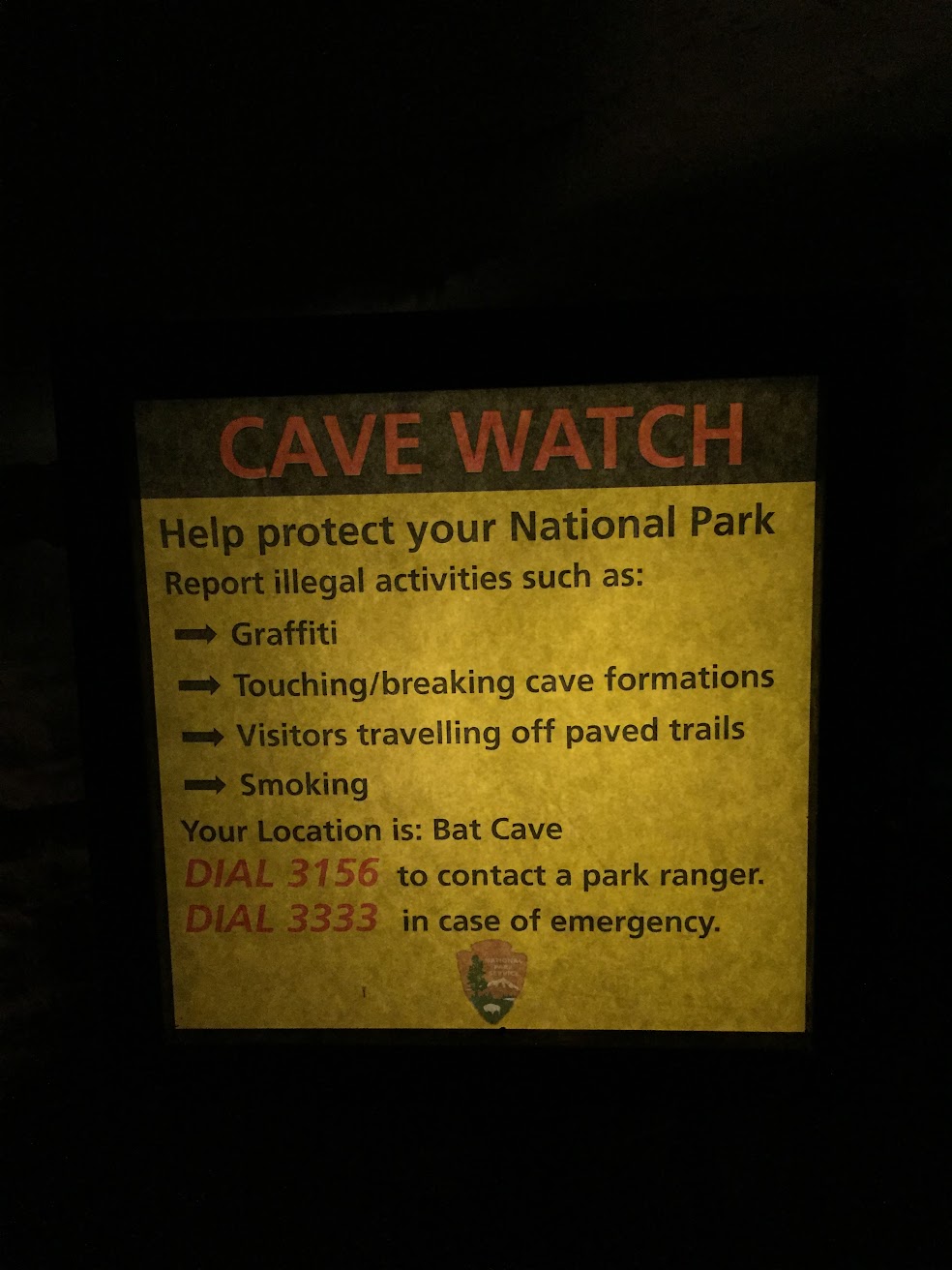
We approached the ticket counter to ask about guided cave tours—sold out. But the park ranger said we could do the self-guided tour. We could take the elevator or the Natural Entrance. “But you’ll take the Natural Entrance. Nothing’s wrong with you. You’ll do it.” “Um…ok” I responded to the park ranger as he caught me eyeing the elevator down to the caves. (I mean, they have built them for a reason, yes?)

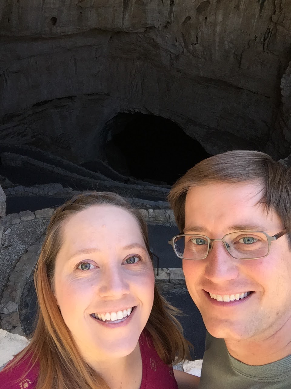
The Natural Entrance trail is 1.25 miles long and takes you 750 feet below ground—if that doesn’t mean much, let me give you one word to sum it up: STEEP! Also dark, and slippery in places. This trail has warning signs! Before you even start!

Carlsbad Caverns National Park

Carlsbad Caverns National Park

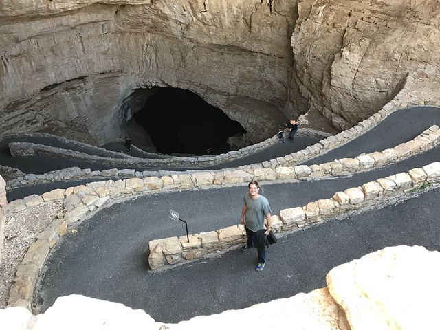
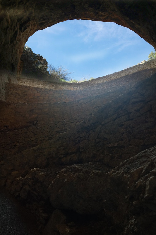
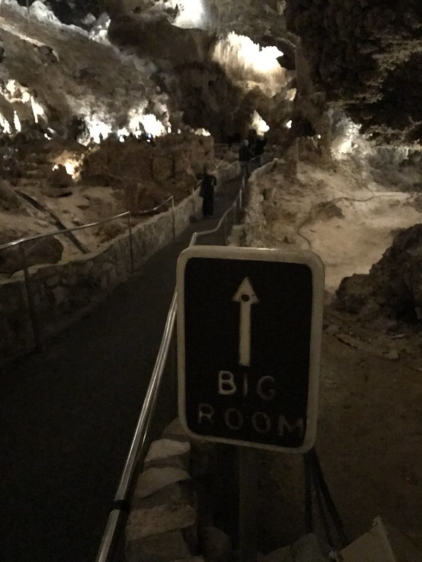
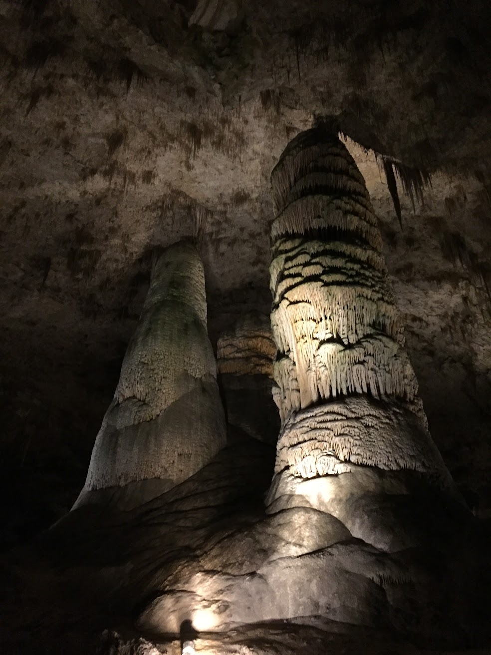
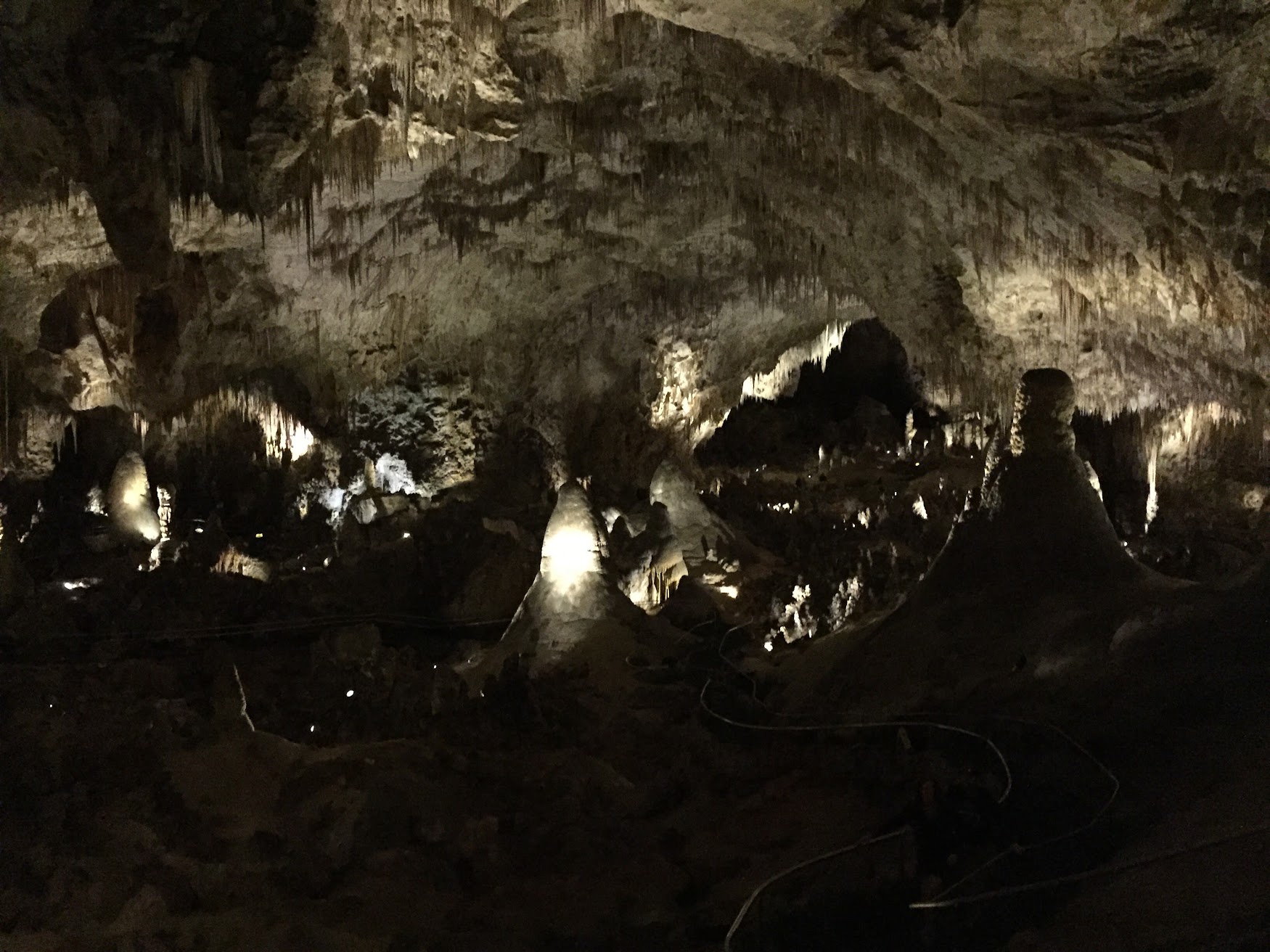
But that gruff old ranger was on to something—the Natural Entrance trail is breathtaking (ha!), and without walking down those steep switchbacks, I don’t think I would have appreciated just how deep underground we went. You can see the trail disappear into the darkness way below you, and then when you finally reach that spot, you discover it disappears into another abyss. Do you see the handrails in the photos below? Try to follow them down, down, down along the trail.

Carlsbad Caverns National Park

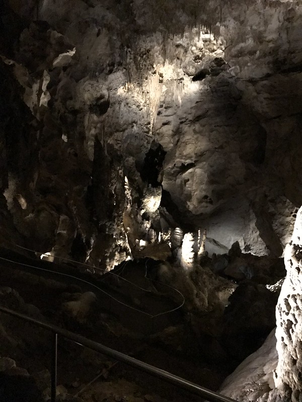
These aren’t the best photos we’ve ever taken (it’s really dark down there!), but hopefully they give you an idea of the scale of these caverns. They are massive!

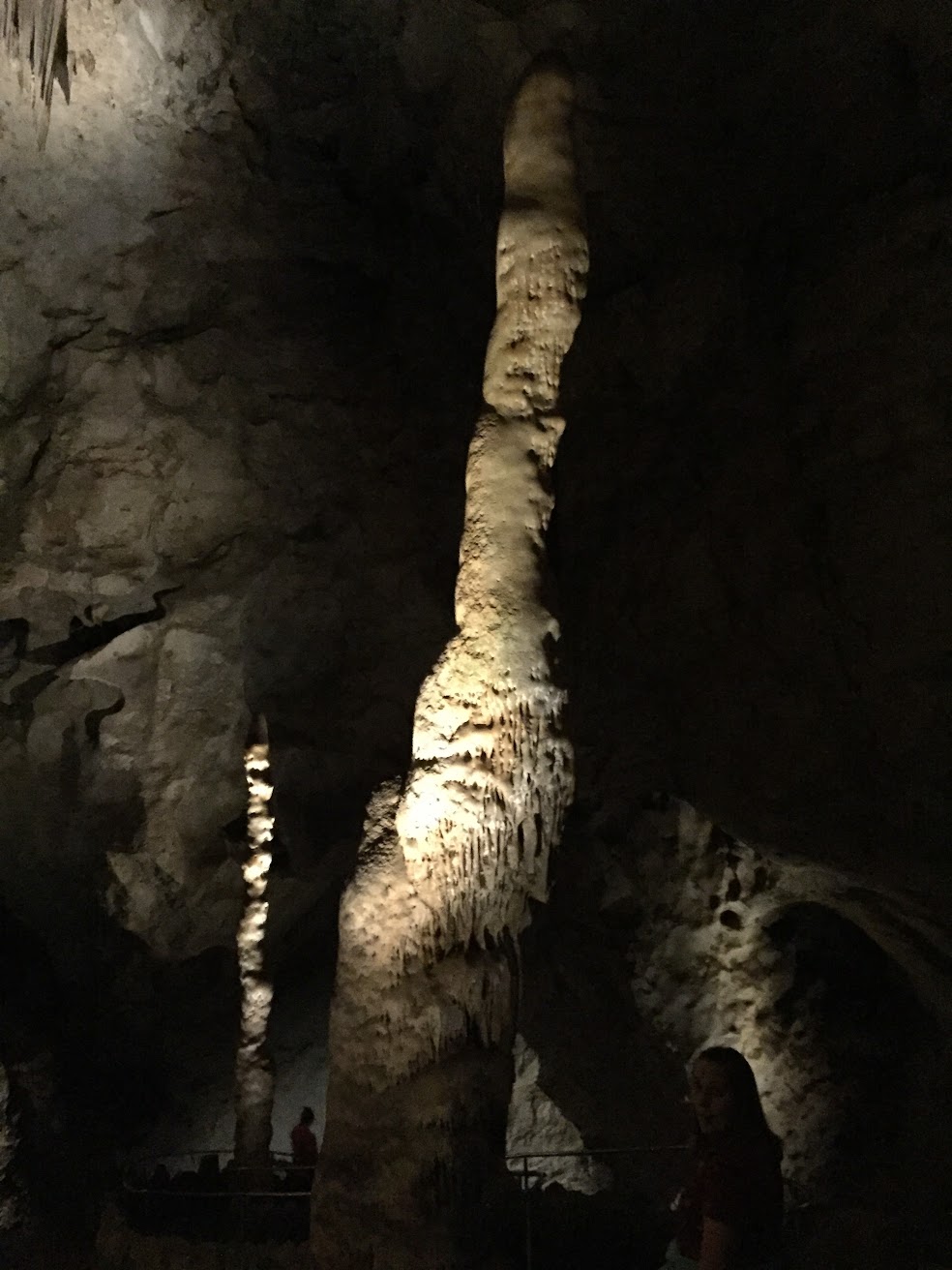
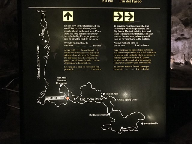
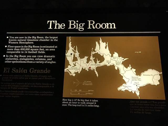
The Natural Entrance trail takes you through lots of different caves, until finally opening up at The Big Room—which is about 8 acres! There’s a mile-long loop trail inside that takes you past all sorts of stalactites, stalagmites, shallow pools, columns, curtains, and bottomless pits.

Carlsbad Caverns National Park

Carlsbad Caverns National Park

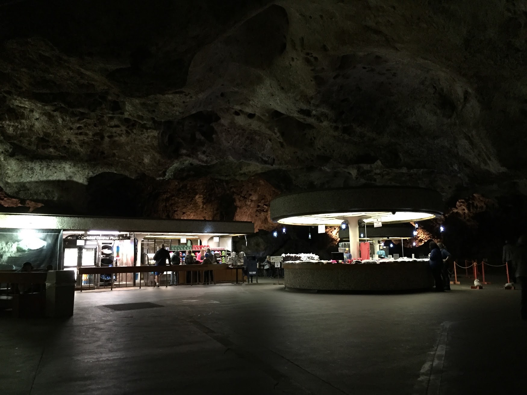
This place is so large, there’s even a gift shop and cafeteria—underground!

Carlsbad Caverns National Park

Do you have the Fraggle Rock theme song stuck in your head now, or is that just me?

Bosque del Apache National Wildlife Refuge

When we mentioned our plans to visit the VLA, our Airbnb host recommended we end the day with a trip to Bosque del Apache for the sunset fly-in. Every evening, thousands of geese and birds fly to a patch of land in the park to settle down for the night. Perhaps you’re thinking what I was…”hmm, what is so special about this?” But it was actually a really impressive thing to watch! There were tens of thousands of birds, and when one small group got worked up, it set off a chain reaction and suddenly there was a riot of honking and flapping.

Bosque del Apache

Bosque del Apache

Bosque del Apache

Bosque del Apache

Bosque del Apache

Bosque del Apache

Bosque del Apache

Curious how loud thousands of birds can be? Check out our short video on Instagram!

Petroglyph National Monument

Petroglyph National Monument

On the outskirts of Albuquerque is the Petroglyph National Monument. There are a few hiking trails, all a short drive from the visitor center. The park ranger we spoke with recommended the Piedras Marcadas Canyon Trail. It’s a relatively easy walk, but be prepared to leave with shoes full of sand!

Petroglyph National Monument

Petroglyph National Monument

The park ranger gave us a map with a short list of petroglyphs to look for at marked stops along the trail. We paused for several minutes at stop one, but couldn’t find the mark! We improved our scouting skills further along the trail, and spotted lots of markings on the basalt rocks.

Petroglyph National Monument

A couple of Jack Rabbits were chasing each other near the trail. Can you spot one in the photo below?

Petroglyph National Monument

Kasha-Katuwe Tent Rocks National Monument

Kasha-Katuwe Tent Rocks National Monument

These tall, cone-like rock formations are called “hoodoos” and are the product of volcanic eruptions millions of years ago. The different bands of color seen in the rocks are different types of ash and volcanic rock deposits.

There are two trails at the park: the Cave Loop and the Slot Canyon Trail. We started with the Slot Canyon Trail, and it was amazing! At some points, the canyon closes in on the trail and the walls are just shoulder-width apart!

Kasha-Katuwe Tent Rocks National Monument

Kasha-Katuwe Tent Rocks National Monument

We got to duck under a huge boulder and scramble up some big rock piles.

Kasha-Katuwe Tent Rocks National Monument

After walking through the canyon, the trail starts climbing a steep hill. When you get to the top, you can walk along to the very tip of the mesa and see for miles all around.

Kasha-Katuwe Tent Rocks National Monument

Kasha-Katuwe Tent Rocks National Monument

Walking back through the slot canyon is just as fun. We got lapped by a couple of groups because we stopped so often to look around and take photos!

Kasha-Katuwe Tent Rocks National Monument

Kasha-Katuwe Tent Rocks National Monument

The Cave Loop trail is a nice walk and there are plenty of tent rocks to see along the way. And of course, the cave! It’s a bit high up in the wall, so you can’t go inside, but it was still pretty neat.

Kasha-Katuwe Tent Rocks National Monument

Kasha-Katuwe Tent Rocks National Monument

We posted a short timelapse video of the canyon on Instagram. Check it out! >

White Sands National Monument

White Sands National Monument

We liked White Sands so much we visited twice in two days! The first day we arrived around 4:00 and took the ranger’s advice to drive the loop during sunset and save hiking for another day. It was cloudy, windy, and cold—but it created a fun illusion that we were driving and walking around on ice.

White Sands National Monument

White Sands National Monument

There are several places to stop along the road and get out to walk on the dunes. One area has an elevated boardwalk and felt a bit more like a visit to the beach.

White Sands National Monument

You might not have a lot of time for exploring before the park closes, but White Sands is definitely worth a visit at the end of the day. The sunset creates some really neat colors and shadows on the dunes.

White Sands National Monument

We went back the next morning with a cloudless sky overhead. And, wow, those sands are bright! Blindingly white!

White Sands National Monument

White Sands National Monument

We passed a few people on the trail, but mostly it felt like we were alone. And it was so quiet out there!

One regret: not buying sleds at the visitor center. Yes, you can go sledding on the dunes! (FYI, frisbees do not work.)

Save

Save

Save

Tohono Chul Park

While visiting Tucson, we spent a few hours walking around the desert trails and gardens of Tohono Chul Park.

Tohono Chul Park

Tohono Chul Park

Tohono Chul Park

What’s neat about this park is their theme of nature, art, and culture. In addition to several walking trails, there are sculptures on the grounds and an art gallery. Signs along the trails taught us about the Tohono O’odham people and the Sonoran Desert.

Tohono Chul Park

Tohono Chul Park

Tohono Chul Park

Tohono Chul Park

Tohono Chul Park

Saguaro National Park (East)

Saguaro National Park

Let’s start with this: it’s pronounced “sa-WAH-ro.” These cacti are only found in the Sonoran Desert, and only up to a certain elevation (they can’t survive the colder temperatures).

Saguaro National Park

The saguaro sprouts from a tiny black seed.

Saguaro National Park

A 6-foot tall saguaro is around 35 years old. They often sprout their arms when they reach about 10–15ft.

Which means saguaros that are super tall, and have lots of arms, are really old!

Saguaro National Park

We took a guided walk (they’re free!) with Park Ranger Jeff, who took us off the trail to see the giant above. That cactus is around 150 years old! The ranger program was very informative! We learned a lot about the saguaro, and also other cacti, local trees, and the impact people and the changing climate have had on this area. We’re now very good at spotting the state tree of Arizona, the Palo Verde:

After the ranger program, we did the Mica View Loop. It was an easy walk that gave us plenty of opportunities to admire the saguaros (and all those other plants we learned about, too).

Saguaro National Park

Saguaro National Park

There are lots of trails and they often intersect. The markers are helpful, but I’d recommend reviewing the trail map with a ranger before you set out.

Saguaro National Park

Saguaro National Park

The saguaro is supported on the inside by woody ribs. When the cactus dies, the ribs sometimes remain standing.

Saguaro National Park

To access some of the trail heads, you have to take the Cactus Forest Loop Drive. This is a one-way 8-mile road that begins and ends at the visitor’s center. It’s a very pretty drive with great views of the desert and surrounding mountains. There are some overlooks along the route for checking out the views or taking a walk to see the Javelina Rocks.

Saguaro National Park

Saguaro National Park

Save

Save

Indian Canyons

About 15 minutes south of Palm Springs is a beautiful place called Indian Canyons. Located on the tribal land of the Agua Caliente band of Cahuilla Indians are miles of trails through desert hills and lush canyon oases.

Indian Canyons

Check out this split rock you have to drive through to get to Palm Canyon!

Indian Canyons

A tribal ranger recommended the Victor Trail in Palm Canyon, followed by the Canyon Loop Trail in Andreas Canyon.

Indian Canyons

As we walked behind the trading post we were greeted with an amazing view of the canyon below — the world’s largest California Fan Palm oasis. Entering the oasis felt like we had been transported to a tropical island.

Palm Canyon

Indian Canyons

Indian Canyons

The towering palms provided a lot of shade as we walked through Palm Canyon. As soon as we turned onto the Victor Trail, we were back in the sun, looking out over the desert. Instead of palm trees and sand, we had barrel cactus and boulders.

Indian Canyons

Indian Canyons

Indian Canyons

Those giant palm trees started looking pretty small as we climbed the hill.

Over at Andreas Canyon, half of the Canyon Loop Trail took us along a ridge above the oasis, and the other half ran right along the face of the canyon wall. That was pretty cool. On one side of the trail was a small stream and huge palm trees, on the other was this towering wall of huge rocks.

Indian Canyons

Indian Canyons

Indian Canyons

Indian Canyons

You know the important things to bring hiking: water, sunblock, etc., but there are two extra things you should bring to Indian Canyons. First, a picnic! There are lots of picnic tables near the oases in Palm Canyon and Andreas Canyon. A really cool spot for lunch. Second, bring wipes to clean your legs at the end of the day! (And don’t forget to shake all the sand out of your shoes, too!)

Indian Canyons

Mt San Jacinto State Park

“It’s 30 degrees cooler AND we get to ride an aerial tram?!” Yup, heading up to Mt San Jacinto State Park for Thanksgiving was the obvious choice. A very steep ride took us up 8500ft in just 11 minutes.

Mt San Jacinto State Park

The tram car might look small in that photo, but it was actually quite spacious. And it rotates! It’s a very slow turn, so it’s not disorienting, and gives everyone a chance to see the views below. (Or straight ahead, if you’re short and stuck in the middle!)

The upper tram station has a couple of lookout balconies, a cafe, restaurant, and a gift shop. Just outside are a few short trails and the Mt San Jacinto State Park.

Mt San Jacinto State Park

We packed day bags for the Round Valley trail, but the park ranger said it was too icy and we should stick to the short trails near the tram station. “He fell twice,” she said, pointing to another ranger, “and he never falls.” Did I forget to mention—there was snow up there! I was glad we followed the ranger’s advice when we came across some slippery parts of the nature trails. The icy patches were only a few feet long here and there, but you know I was freaking out!

Mt San Jacinto State Park

The trails led us to big trees, big rocks, and big views…

Mt San Jacinto State Park

Mt San Jacinto State Park

…which led to big appetites! The tram station cafe served a traditional Thanksgiving feast, and it was delicious!

Thank you for following our adventures this year!

Save

Whitewater Preserve

We got up before 6am, ON A WEEKEND, to see hot air balloons launch from Cathedral City. What happened when we arrived? Cancelled! Only one balloon went up for tethered rides. But we were rewarded for getting up early with this vivid rainbow above the San Jacinto Mountains.

Rainbow above San Jacinto Mountains

In the afternoon we went hiking at Whitewater Preserve. The hills on either side blocked the sun, so it was shaded and cool. The ground near the small river was very soft grey sand, and there were smooth river rocks everywhere.

Whitewater Preserve

Whitewater Preserve

Whitewater Preserve

In other areas the trail passed over a small stream and through a small crop of very tall river reeds (only a few steps really, but that part freaked me out).

Whitewater Preserve

The Preserve is surrounded by the San Gorgonio Wilderness. For real, there is a sign that says you are entering the wilderness:

Whitewater Preserve

Although I suggested we might not be ready for actual wilderness, we kept on the path anyway and came upon the Pacific Crest Trail. We walked on that for a short bit before heading back.

Whitewater Preserve

Whitewater Preserve

Thankfully there were no rattlesnake or mountain lion sightings!